Sunday, November 29, 2009

¡Machu Picchu RAPIDO!

For the seasoned world traveler (read: Didi), being in the Sacred Valley of Peru and not visiting Machu Picchu is like going to Paris and shielding your eyes from the view of the Eiffel Tower.  So Didi made it clear that this was a trip we would all be doing together during her visit.

Machu Picchu is not an easy site to get to.  This probably has everything to do with the reason it was re-discovered in such great shape... the Spanish never found it.  Since it is so remote, there are but two ways to get there:  walk four days on the Inca trail (the way I always imagined getting to Machu Picchu), or ride a train to the town of Aguas Calientes and ride in a diesel bus up a narrow dirt road to the foot of the ruins.  Since we had such a short period of time we had to go by train. 

The atmosphere around Machu Picchu was more reminiscent of Epcot Center than the Amazon Basin.  Just as I feared.  It was a kind of tourist purgatory overflowing with trinket shops and beer gardens squeezed between the near vertical walls of the Urubamba River canyon.  After such an inauspicious approach I was prepared to be disappointed by the ruins.

I was wrong.

No words or images can do justice to the feeling of standing on the ridge of Machu Picchu, catapulted as it is, thousands of feet above the tight oxbow of the Urubamba river that surrounds it on three sides like a moat.  I won't attempt to share my shallow knowledge of the site and its construction here -- you'd be better served to read a book -- but I will post images with some semblance of captions.


The train pulling out of Urubamba

Pedro, superguide, was by mom's side every step of the way.  


The quintessential view of Machu Picchu.  If you turn your head 90˚ to the right, you will see the profile of a face formed by Huayna Picchu, the ridge behind the ruins.  Coincidence?  I think not.

 
The wall that knocked Hiram Bingham's socks off.


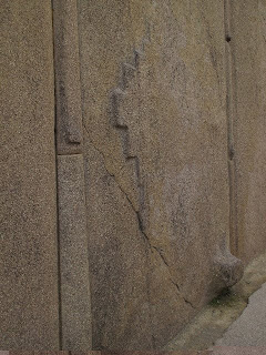
Double doorway near the Temple of the Sun.  Notice the two different types of stone work -- the left side was part of a dwelling while the right was part of a holy temple.  Also notice the anti-seismic angles of the door frame.

 
Two examples of the extraordinarily organic architecture used by the Inca, seamlessly incorporating the granite bedrock into their constructions.

 
Detail of the head of a condor carved into the bedrock above, and its outstretched "wings" below.
To the Inca the condor was a totem that helped souls bridge the gap from the world of the living to the realm of the Gods.  


Steep terraces blanket the flanks of the ridge on all sides.  Even though they look uniform, beneath the surface each of these terraces has three distinct layers for optimum irrigation and growing conditions.  The first layer is gravel, next is sand, and the last layer is rich mud hauled up from the banks of the Urubamba river.  It is difficult to imagine how much work and skill it must have taken to etch these earthworks into the steep granite cliffs.  


Our friendly steward whips up the best Picso Sour in Peru (really!) while we head back to Cusco on the "Vista Dome" train.

The four hour ride from Aguas Calientes was broken up by a few traditional dance presentations and,
I kid you not, a fashion show of alpaca outerwear, complete with a pumping euro-techno soundtrack, modeled by the stewards and stewardesses who prepared our drinks.


Brother David trying valiantly to block out Didi's dramatic oral reading of "The Madoff Chronicles" as we steam through the Andes on the train back to Cusco.


UNESCO has placed Machu Picchu on the list of most endangered archeological sights, and I can see why.  The Peruvian government has a curious habit of reconstructing ruins to make them look nicer, but in their fervor for tidiness they are likely erasing important information that could fill in the gaps of the stories of the people who made them.  Additionally, the town of Aguas Calientes (whose name is now being changed to El Pueblo de Machu Picchu) is poorly equipped and situated for the hordes who come to see the place.  The glory of Machu Picchu's location, preservation, and history are nearly equaled by the grotesque nature of the tourist circus surrounding it.  There are some measures being taken to better preserve the ruins in their original state, and the number of visitors is limited per day, so not all the news is bad. 

Even after having said all that,  I was so amazed by the place that (perhaps a bit selfishly...)  I can't wait to get back to it.    Being there is such an astounding experience that I encourage all of you reading this to do the same.

Tuesday, November 24, 2009

Brother Adventure to Pisac

My brother David and I decided to head to the town of Pisac last week.  The town itself is famous for its enormous and bustling crafts market, but it also abuts the Inca ruins that share the same name.  We had heard that the ruins were big, much bigger in fact than those at Machu Picchu, and we thought we would have a look.  My friend Jean-Jacques Decoster gave me a copy of a great little Cusco guidebook written by local expat Peter Frost which outlines a five hour hike along a ridge adjacent to the ruins.  We decided to give this one a try as it promised amazing views of the ruins from above.

We started by walking right out of the center of town at 3000 meters and began gaining altitude rapidly on the steep cobblestone walkway.  The paving soon gave way to dirt trails switchbacking from one end of the narrow valley to the other.  When we came to a "T" we knew to go left even though this sent us up and away from the ruins. 

Cactus in bloom with the town of Pisac around 700 feet below us.

We ascended the headwall of the narrow valley only to find ourselves in a new drainage, filled with a dense stand of eucalyptus trees.  After climbing up to around 3400 meters David suggested we climb up and out of this wooded valley back toward the direction of the ruins.  This was a great call.  As we topped out on the grassy field above, we caught our first view of the ruins, and it was staggering.


Along a sharp, exposed ridge sat building upon building, rising up from its spine.  Almost every low-angled flank of the ridge was covered in a vast array of agricultural terraces that from our vantage point, resembled the layers of cardboard used by architects to represent topography on their models.

As we came closer to the ruins we were cliffed out and resumed heading uphill along the edge of the precipice.  At around 3600 meters we came to a trail that descended a lower angle section of the cliff and we made our way to a valley floor.

We ran into six boys sitting on a rock here, dressed in their school uniforms.  We struck up a conversation with them and found out that they have no high school in their tiny town up in the mountains, so they make the trek to Pisac each day for their education.  Neither David nor I could believe it when they told us it takes three hours to walk down to school every day, and four hours to walk back up.  Yes math fans, that equals seven  hours of walking every day just to get to school.


And look at how smiley they are!  They do the walk all year long, sometimes in rain and freezing temperatures, wearing nothing but sandals made of old tires on their feet.

After saying goodbye to our new friends we headed for the ruins.  The small valley we exited to gain the saddle where the ruins begin is also the terminus of a spring pouring out of the mountainside, and into a series of carved basins.  Climbing along the ridge top we came to the first set of buildings.  Some of these were accessible via steep stone stairs while others required a trip up a homespun ladder. 


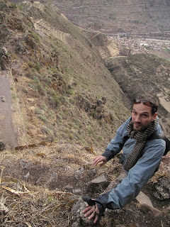
We attempted to continue along the knife edge of the ridge, but were stopped by a cliff.  Descending toward the more "touristy" trail, a thin thread of a path caught my eye heading back up toward the high line.  We followed it and after a little third class scramble it deposited us back on the spine of the ridge.

I have always been partial to ridges.  According to French mountain guides there is no safer place to be in the alpine environment.  Nothing is going to fall on you from above and you have a commanding view of the terrain you are traveling through.  Ridges are also preferable to drainages because they are comparatively dry and unvegetated.  This ridge walk began characteristically fun and airy, but it quickly became tense and hairy.
 

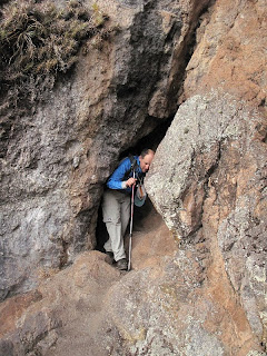
After a pleasant trail of loam snaking its way in and around the rock outcroppings dotting the ridge crest, we were presented with an ancient staircase.  The stairs descended at a very steep angle to a 90˚ turn that if you missed, would send you flying off a 500 foot cliff to the valley below.  I was taking enormously deep breaths to keep my heart rate from reaching its maximum cadence as I approached the scary turn.  To my amazement, in front of me was a slit of a tunnel cutting 100 feet through the core of the mountain.


After regaining our composure we continued along the ridge trail which soon finished with a 50 foot 3rd class scramble to get to the easier trail below.
We later found out that by traversing this ridge we had walked along one of the least adulterated Inca trails in the region.  I couldn't stop thinking about what it must have been like to build this thing.  It was an extraordinary experience to encounter the ruins this way, no doubt enhanced by the moderate level of adrenaline coursing through our veins.

Once back on terra-firma  we made our way from the residential sector to the religious center of Pisac.  The stone work on holy buildings is astonishing.  The lines are clean, joints are perfect, and the structures are more or less intact nearly 600 years after having been built. 


 As the sun was setting we continued to make our way back down to the valley floor, 1500 feet below us.  The ridge continued, as did the ancient buildings.  The photo below shows the former hospital of Pisac.


The location of Pisac on the crest of a ridge began to get me thinking.  I have spent a fair amount of time walking about in the mountains, and a key element I always look for in a campsite is access to water.  I also prefer a campsite with the best possible view.  I look around and make sure that I will not be overly exposed to any objective hazards like falling rocks, dead trees, or floods.   If I were living hundreds of years ago and was looking for an ideal place to build a dwelling, the ridge at Pisac would have been at the top of my list.  Not only would it have met my modern backpacking standards, it would also have been nearly impossible for marauders to invade.  Add to this the incredible earthworks that the Inca were able to accomplish in the form of agricultural terraces and you have a grand slam.  The settlement at Pisac was as much a work of art as it was a self sustaining city perched on a knifes-edge ridge soaring thousands of feet above the fertile valley floor of the Urubamba River.

 
We reached the main plaza just at dusk.  Our easy walk had turned into more of an adventure than we had planned on, and the warm glow of the businesses in town was a welcome sight.  We quickly found a cab back to Urubamba and during lulls in the conversation hung our heads out of the open windows as we drove through the pitch black night.


Sunday, November 22, 2009

Bernie Madoff and the Fall of the Inca

As an aside, I have to explain that my mother, throughout her trip to Peru was glued to a tell-all book about our former neighbor and acquaintance, Bernard Madoff.  Here we were, traveling through what is arguably the most fantastic and intact set of pre-columbian ruins in the Americas, and my mother was fixated on gossip about Madoff and his infamous ponzi scheme.

While walking down from the Ollantaytambo ruins Di-di was laden as usual with the most ridiculous assortment of unnecessary items.  She had scarves, reading glasses dangling from her neck, her camera on a lanyard, a variety of sweaters, a walking stick, and a large brown bag containing  tissues, journals, bottles of lens cleaner,  and purloined baked goods and dinner mints from whatever restaurants we had visited in previous days.  In addition to this payload was the "Madoff Chronicles" held against her chest.

The path was not smooth and was somewhat exposed as it paralleled a fast moving irrigation ditch.  Sure enough, Bernie's book of secrets fell out of her arms and plopped squarely into the rapidly moving water.  I heard mom yell "Ohhh!" and saw a black book floating down the stream past me.  I had no idea what this book was -- I assumed it was one of her journals (she keeps a few in that brown bag) -- so I went into high-alert rescue mode.  I tore down the path overtaking the floating tome, and dropped to my belly in order to grab it before the channel went underground.  Submersing my arm up to the elbow I wrapped my fingers around the binding and yanked it from the water.  To my surprise and chagrin I had not rescued an irreplaceable relic with anecdotes written in my mother's hand about her many trips.  No, I had in my hands a collection of the most puerile tidbits concerning the life of Bernie Madoff.

The irony of rescuing this chronicle of thievery from the rushing waters of a canal built by a culture whose entire existence had been stolen by the Spaniards was not lost on me.  As my brother said, the only disappointment with the outcome was that I didn't let the Madoff Chronicles float down to the river, out of our reach and out of our lives forever.

Saturday, November 21, 2009

A Day in Patacancha, Huilloq, and Ollantaytambo (by Lawrs)

My brother thought it might be a good idea to do an organized tour of the Sacred Valley of the Urubamba River on Sunday, and it turns out he was absolutely right.  The cost was significant, but having the use of a solid vehicle (complete with capable driver) and a knowledgeable guide made our day really amazing.  At 9:30 AM the six of us boarded a spacious Mercedes Sprinter  with our guide, Erica, and our driver, Ronald.  Our itinerary was to head north to Ollantaytambo and then up, up, up to the villages of Huilloq and Patacancha, both above 12,000 feet in elevation.  We would eat a picnic lunch and then end the day with a walking tour of the riverside ruins of Ollantaytambo, one of the last holdouts of Mancu Inca after his escape from Spanish occupied Cusco.

Our first stop in Ollantaytambo was all about shopping.  In return for intruding on  their turf, the rural folks appreciate a bit of an incentive.  Instead of just handing out money (which may be spent on less healthy treats like candy, alcohol, cigarettes, etc.) many tourists have made the switch to handing out  wholesome goods ranging from bread and fruit to pencils and notebooks.  We walked through town and picked up bags of coca leaves to share with the grownups and bread and pencils to give to the kids.


Once we had our booty ready to distribute we drove up a narrow, cratered dirt road for forty minutes past enormous cliff faces dropping thousands of feet to the valley floor.  Bit by bit the trees began to thin and finally disappeared  as we passed above 12,000 feet.  We had arrived in the small town of Patacancha.


Patacancha is a village where the traditional way of life is "preserved" (insofar as this is actually possible in this age of ubiquitous internet access and cell phones...)  through tourism and international grants that help the local people sell their weaving to a global clientele.  As soon as we stepped off the bus, men and women in brightly colored clothing began to shuffle towards us with heavy lliqlas full of their work suspended on their shoulders.  It was business time in Patacancha.


We made our way down into a courtyard where a group of five women, most with their children at their side, had spread out a selection of hats, belts, capes, skirts, vests, shawls and dolls for us to buy.  There were two men who set up apart from the women and had only blankets and belts for sale.  My brother and I shared coca leaves with the men while Sophia and Isabel played with the local children, distributing pencils to them and tying on their hats.  I too took a hat for a trial run as evidenced in the photo below.   Krista was helping my mom bargain in Quechua and we all eventually bought some really beautiful weavings. 


Heading back toward Ollantaytambo we came to the town of Huilloq, which has a warehouse built by an NGO for the display and sale of textiles.  This was a larger town than Patacancha  and there were a lot of kids following us around to get bread and pencils.  We actually burned through all 30 loaves in about ten minutes.  I asked the kids about their school and was happy to hear that they enjoyed it and that they were learning in both Spanish an Quechua.  Some of the smaller kids were fascinated with Sophia and Isabel and wouldn't leave their sides.


It was sobering to see how some of the children were barefoot, walking through the muddy dirt paths with filthy clothing and filthy faces.  On the other hand, it was amazing to see how that didn't really make any difference to Sophia and Isabel.  Kids are kids, and they all had a really nice time talking and playing together despite the vast differences between their lives.  
We stopped in a pull-off  on the narrow road where Ronald and Erica feverishly set up a picnic table and brought out platter after platter of amazing food for our picnic lunch.  The quality of the setting was commensurate with that of the food and there was so much of it that we couldn't come close to finishing it.  We stopped campesinos who were walking by to offer them fruit and bread to carry back to their houses.  David also shared some coca with a woman who was so excited to get some.

After packing up our lunch and getting back in the van we continued back down the valley toward the ruins of Ollantaytambo.  The walls of the valley were striking in the late afternoon light.


The ruins of Ollantaytambo are squeezed into a tight drainage on the south side of a small, but steep mountain.  There are terraces climbing up to a temple with commanding views of the valley below in every direction.  The stones used to build this temple are impossibly large.  They were quarried 12 kilometers from the construction site and then transported here (how exactly they were moved is still up for debate) and assembled with such skill that you could not pass a piece of paper between the mortarless joints.  Someone told us that the Inca used this particular pink granite because of its high quartz content.  Quartz crystals were prized for their "energy content" and so were a perfect choice for the walls of the Temple of the Sun.  Whether or not you believe this, the visual impact is breathtaking.


 The path from the Temple of the sun across the sheer face of the mountain to another set of terraces was airy, to say the least.  We began our descent to the river as the sun sank behind the ridges defining the valley.  We walked along the elaborate irrigation canals laid out on the valley floor on the way to the van.
 
The day was honestly mind boggling, almost too much to take in in such a short time.  On the drive back we could see big storm clouds over Cusco to the south and we were very thankful that we happened to be where the rain wasn't on this long and extraordinary day.