 My brother David and I decided to head to the town of Pisac last week. The town itself is famous for its enormous and bustling crafts market, but it also abuts the Inca ruins that share the same name. We had heard that the ruins were big, much bigger in fact than those at Machu Picchu, and we thought we would have a look. My friend Jean-Jacques Decoster gave me a copy of a great little Cusco guidebook written by local expat Peter Frost which outlines a five hour hike along a ridge adjacent to the ruins. We decided to give this one a try as it promised amazing views of the ruins from above.
We started by walking right out of the center of town at 3000 meters and began gaining altitude rapidly on the steep cobblestone walkway. The paving soon gave way to dirt trails switchbacking from one end of the narrow valley to the other. When we came to a "T" we knew to go left even though this sent us up and away from the ruins.
Cactus in bloom with the town of Pisac around 700 feet below us.
We ascended the headwall of the narrow valley only to find ourselves in a new drainage, filled with a dense stand of eucalyptus trees. After climbing up to around 3400 meters David suggested we climb up and out of this wooded valley back toward the direction of the ruins. This was a great call. As we topped out on the grassy field above, we caught our first view of the ruins, and it was staggering.


Along a sharp, exposed ridge sat building upon building, rising up from its spine. Almost every low-angled flank of the ridge was covered in a vast array of agricultural terraces that from our vantage point, resembled the layers of cardboard used by architects to represent topography on their models.
 As we came closer to the ruins we were cliffed out and resumed heading uphill along the edge of the precipice. At around 3600 meters we came to a trail that descended a lower angle section of the cliff and we made our way to a valley floor.
 We ran into six boys sitting on a rock here, dressed in their school uniforms. We struck up a conversation with them and found out that they have no high school in their tiny town up in the mountains, so they make the trek to Pisac each day for their education. Neither David nor I could believe it when they told us it takes three hours to walk down to school every day, and four hours to walk back up. Yes math fans, that equals seven hours of walking every day just to get to school.
And look at how smiley they are! They do the walk all year long, sometimes in rain and freezing temperatures, wearing nothing but sandals made of old tires on their feet.
After saying goodbye to our new friends we headed for the ruins. The small valley we exited to gain the saddle where the ruins begin is also the terminus of a spring pouring out of the mountainside, and into a series of carved basins. Climbing along the ridge top we came to the first set of buildings. Some of these were accessible via steep stone stairs while others required a trip up a homespun ladder.
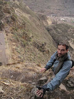
We attempted to continue along the knife edge of the ridge, but were stopped by a cliff. Descending toward the more "touristy" trail, a thin thread of a path caught my eye heading back up toward the high line. We followed it and after a little third class scramble it deposited us back on the spine of the ridge.
I have always been partial to ridges. According to French mountain guides there is no safer place to be in the alpine environment. Nothing is going to fall on you from above and you have a commanding view of the terrain you are traveling through. Ridges are also preferable to drainages because they are comparatively dry and unvegetated. This ridge walk began characteristically fun and airy, but it quickly became tense and hairy.
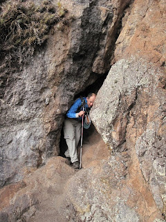
After a pleasant trail of loam snaking its way in and around the rock outcroppings dotting the ridge crest, we were presented with an ancient staircase. The stairs descended at a very steep angle to a 90˚ turn that if you missed, would send you flying off a 500 foot cliff to the valley below. I was taking enormously deep breaths to keep my heart rate from reaching its maximum cadence as I approached the scary turn. To my amazement, in front of me was a slit of a tunnel cutting 100 feet through the core of the mountain.


After regaining our composure we continued along the ridge trail which soon finished with a 50 foot 3rd class scramble to get to the easier trail below.
 We later found out that by traversing this ridge we had walked along one of the least adulterated Inca trails in the region. I couldn't stop thinking about what it must have been like to build this thing. It was an extraordinary experience to encounter the ruins this way, no doubt enhanced by the moderate level of adrenaline coursing through our veins.
Once back on terra-firma we made our way from the residential sector to the religious center of Pisac. The stone work on holy buildings is astonishing. The lines are clean, joints are perfect, and the structures are more or less intact nearly 600 years after having been built.
 As the sun was setting we continued to make our way back down to the valley floor, 1500 feet below us. The ridge continued, as did the ancient buildings. The photo below shows the former hospital of Pisac.
The location of Pisac on the crest of a ridge began to get me thinking. I have spent a fair amount of time walking about in the mountains, and a key element I always look for in a campsite is access to water. I also prefer a campsite with the best possible view. I look around and make sure that I will not be overly exposed to any objective hazards like falling rocks, dead trees, or floods. If I were living hundreds of years ago and was looking for an ideal place to build a dwelling, the ridge at Pisac would have been at the top of my list. Not only would it have met my modern backpacking standards, it would also have been nearly impossible for marauders to invade. Add to this the incredible earthworks that the Inca were able to accomplish in the form of agricultural terraces and you have a grand slam. The settlement at Pisac was as much a work of art as it was a self sustaining city perched on a knifes-edge ridge soaring thousands of feet above the fertile valley floor of the Urubamba River.
We reached the main plaza just at dusk. Our easy walk had turned into more of an adventure than we had planned on, and the warm glow of the businesses in town was a welcome sight. We quickly found a cab back to Urubamba and during lulls in the conversation hung our heads out of the open windows as we drove through the pitch black night.


No comments:
Post a Comment